Маркетплейс твоей Страны![]()


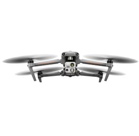


Дрон Autel EVO MAX 4T Standard Bundle (без аккумулятора) 102002265
Нет в наличии
Код:003194687
(0.0)
 Отделение Новой Почты
По тарифам перевозчика
Характеристики Дрон Autel EVO MAX 4T Standard Bundle (без аккумулятора) 102002265
| Производитель | |
| Основное: Тип | квадрокоптер |
| Основное: Максимальная скорость, м/с | 23 (без вітру поблизу рівня моря). Максимальна швидкість у режимі Ludicrous становить 19 м/с під час роботи в регіонах ЄС. |
| Основное: Максимальная высота, м | 4000 |
| Основное: Время полета, мин | 42 |
| Основное: Макс. угловая скорость | 120 °/с рыскание,300°/с тангаж |
| Основное: Диапазон рабочих температур | -20°C - +50°C |
| Летательный аппарат: Питание модели | LiPo 4S 14,88 V/ 120wh (Температура зарядки от -20°C до 45°C. Когда температура ниже 5°C, функция самонагрева будет автоматически активирована. По крайней мере, около 10% остаточной мощности для отопления) |
| Комплектация: Другое | Зарядное устройство,пропеллеры по часовой стрелке x3/ против часовой стрелки x3,micro SD на 64 ГБ,инструкция,кабель питания,крышка подвеса,джойстики,контроллер,отвертка,дрон,зарядное устройство контроллера и зарядный кабель,шнурок контроллера,кабель для передачи данных,крышка контроллера |
| Размеры и масса летательного аппарата: Размеры | 56.2x65.1x14.7 (в розкладеному стані з пропелерами), 31.8x40x14.7 см (в розкладеному стані, без пропелерів), 25.7x14.5x13.1 см (у складеному вигляді, без пропелерів) |
| Размеры и масса летательного аппарата: Вес, кг | 1.6 |
| Основное: Скорость подъема, м/с | 8 |
| Основное: Скорость спуска, м/с | 6 |
| Оснащение: GPS | Есть |
| Оснащение: Дополнительно | ГЛОНАСС,GALILEO,BeiDou |
| Пульт управления: Встроенный дисплей (диагональ), дюйм | 7.9 |
| Пульт управления: Разрешение экрана | 2048x1536 |
| Пульт управления: Яркость экрана | 2000 ніт |
| Пульт управления: Память | ROM 128GB |
| Пульт управления: Питание пульта | Аккумулятор 5800мАч/ 11,55 В/ 67 Вт·ч/ Время зарядки: 120 мин |
| Пульт управления: Частота пульта | 2.400 - 2.4835 ГГц,5,725 - 5,850 ГГц кроме MIC,5.150-5.250 ГГц только MIC |
| Пульт управления: Максимальный радиус действия дистанционного управления, км | 20 (FCC), 8 км (CE) |
| Пульт управления: Максимальное время автономной работы | ~2 ч (макс. яркость),4.5 ч (50% яркости) |
| Пульт управления: Степень защиты | IP43 |
| Пульт управления: Дополнительно | GPS+GLONASS+Galileo+Beidou,Wi-Fi Wi-Fi Direct, Wi-Fi Display, 802.11a/b/g/n/ac Поддержка 2 x 2 MIMO Wi-Fi,Рабочая температура от -20°C до 40°C |
| Летательный аппарат: Емкость батареи квадрокоптера, мАч | 8070 (Гаряча заміна підтримується) |
| Летательный аппарат: Вес аккумулятора, г | 520 |
| Комплектация: Кейс | Есть жорсткий |
| Комплектация: Рекомендуем приобрести | 102002188 |
| Основное: Максимальное время зависания (без ветра), мин | 38 |
| Основное: Максимальное сопротивление ветру | 12 м/сек (взлет и посадка) |
| Основное: Макс. угол наклона | 35° |
| Оснащение: Объем внутренней памяти, Гб | 128 з 64 ГБ вільного місця (об’єм вільного місця, що залишився, залежить від версії мікропрограми) |
| Камера (основная): Матрица | 1/2 "CMOS Эффективные пиксели: 48 МБ |
| Камера (основная): Объектив | Фокусное расстояние: 11,8-43,3 мм (35 мм, эквивалент: 64-234 мм),Диафрагма: f/2.8-f/4.8,Расстояние фокусировки: 5 м ~ ∞ |
| Камера (основная): Чувствительность, ISO | 100-12800 (фото),100-6400 (фото),100-6400 (авто) |
| Камера (основная): Разрешение фото, точек | 8000 x 6000 / разрешение видео 7680×4320 |
| Камера (основная): Подвес для камеры | Есть 3-осьовий механічний карданний підвіс (тангаж, рискання, крен) |
| Размеры и масса летательного аппарата: Колесная база, мм | 466 |
| Основное: Контролируемый диапазон подвеса | от -90° до +30° |
| Тепловизионная камера: Датчик | Неохлажденный микроболометр VOx |
| Тепловизионная камера: Объектив | Поле зору: 42° |
| Тепловизионная камера: Фокусное расстояние | 13 / Діафрагма: f/1.2/ Відстань фокусування: 6 м ~ ∞ |
| Тепловизионная камера: Разрешение сенсора | 640x512 |
| Тепловизионная камера: Размер пикселя, мкм | 12 |
| Тепловизионная камера: Диапазон температур | Режим высокого усиления: от -20° до +150°,Режим низкого усиления: от 0° до +550° |
| Тепловизионная камера: Разрешение видео | 640×512@25FPS |
| Основное: Грузоподъемность, кг | 1.999 |
| Оснащение: Рабочая частота Wi-Fi | 2,400 - 2,4835 ГГц,5,150 - 5,250 ГГц (CE/FCC/MIC),5,725 – 5,850 ГГц (кроме микрофона) |
| Камера (основная): Дополнительно | Компенсация экспозиции ±3EV 0,3EV/шаг |
| Лазерный дальномер: Точность измерения | ± (1 м+D×0,15%) D це відстань до вертикальної поверхні |
| Лазерный дальномер: Диапазон измерения | от 5 м до 1,2 км |
| Лазерный дальномер: Рабочая частота | 2,4G/5,8G/900MHz 900 МГц применяется только для регионов FCC |
| Лазерный дальномер: Максимальное расстояние передачи (без помех) | 20 км FCC,8 км CE |
| Лазерный дальномер: Независимые сети | Autel Smart Controller V3 |
| Лазерный дальномер: Мощность передатчика (EIRP) | 2,4 ГГц: <28 дБм (FCC), <20 дБм (CE/SRRC/MIC),5,8 ГГц: <28 дБм (FCC/SRRC), <14 дБм (CE),5,15-5,25 ГГц: < 23 дБм (FCC/CE),902-928 МГц: <30 дБм (FCC),5,65-5,755 ГГц: <27 дБм (MIC) |
| Радар миллиметрового диапазона: Частота | 60 ГГц/24 ГГц |
| Радар миллиметрового диапазона: Диапазон обнаружения | Радар 24 ГГц: Вниз: 0,8-12 м,Радар 60 ГГц: Вверх: 0,3-20 м/Вниз: 0,15-80 м/Вперед и назад: 0,3-50 м |
| Радар миллиметрового диапазона: FOV | По горизонтали (6 дБ): ±60°/±22° (24Г/60Г),По вертикали (6 дБ): ±30°/±20° (24Г/60Г) |
| Радар миллиметрового диапазона: Операционная среда | Радиолокационная система миллиметрового диапазона волн 60 ГГц поддерживает избегание помех в любую погоду для стекла, воды, проводов, построек и деревьев. Расстояние обхода помехи зависит от способности помехи отражать электромагнитные волны и ее размера.,Радар миллиметровой волны 24 ГГц поддерживает зондирование вниз, и его диапазон восприятия зависит от материала земли. Например, диапазон чувствительности цементного грунта составляет 12 метров, а диапазон чувствительности травы толщиной более 3 см менее |
Читать полностью
Сховати
Описание Дрон Autel EVO MAX 4T Standard Bundle (без аккумулятора) 102002265
AUTEL EVO MAX 4T
Special Defense Version
- Strong anti-inteference
- No need for activation when first time powering on
- Manual FCC/CE switch
- No limits in the frequency channel
- No No-fly-zone
- Image transmission can be switched off
- AI weapon recognition
Features
- 50MP Zoom Camera or 0.0001 LUX Starlight Camera
- 640×512 Thermal Resolution
- Hot-Swappable Batteries
- IP43 Weather Rating
- 42 min Max. Flight Time
- 12.4 Miles Transmission Range
- 13,124 ft Service Ceiling
- 27 mph Max. Wind Resistance
- 720° Obstacle Avoidance
Auto Path Finding
Autel's Autonomy Engine collects surrounding environmental data and plans 3D flight paths through complex environments such as mountains, forests, and buildings. Use cases include rapid 3D scene reconstruction, public safety overwatch, industrial inspection, and land surveying.
Navigation in GPS Denied Environment
Advanced sensors allow the EVO Max series to navigate within hardened structures, underground, or in environments without GPS.
Accurate Object Identification and Tracking
Based on Autel's AI recognition technology, the EVO Max series can automatically identify and lock onto different types of targets such as heat sources, moving people, or vehicles and achieve high-altitude tracking and data collection for law enforcement.
No Blind Spots
The EVO Max series is the only commercial drone that combines traditional binocular vision systems with millimeter wave radar technology. This allows the onboard Autel Autonomy Engine to perceive objects down to 0.5 inches, eliminating blind spots and enabling operation in low light or rainy conditions.
Anti Jam, Anti Interference
The EVO Max series uses advanced flight control modules and algorithms specially designed to counter RFI, EMI, and GPS spoofing. This enables the EVO Max series to fly confidently near power lines, critical structures, and in complex areas.
A-Mesh 1.0
The Industry's First Mesh Networking
EVO Max series features the new A-Mesh system, enabling drone-to-drone autonomous communication, connection, and collaboration.
Enhanced Range
Communication nodes can be placed statically on hills or poles to provide full coverage to an area, or a swarm of drones can provide mobile communication points to extend the coverage of the entire group.
Beyond-Line-of-Sight Applications
With A-Mesh, multiple drones in the vicinity can act as relay points to greatly improve BVLOS operation effectiveness.
Enhanced Anti-Interference
The EVO Max series can communicate seamlessly with other drones in the vicinity, unlike a traditional chain structure. If a single drone fails or exits unexpectedly, the entire system will independently self-organize and continue to relay critical information.
Full-Fleet Control
Multiple drones can be controlled autonomously by 1 pilot or by a group of pilots simultaneously with or without LTE coverage.
Autel SkyLink 3.0
SkyLink 3.0 system of The EVO Max Series comes with 6 antennas, 4 frequency bands, AES-256 encryption, and optional 4G integration to provide users with the most advanced flight capabilities ever in an EVO.
- 12.4 miles Image Transmission Distance
- <150ms Latency
- 1080P@60FPS Real-Time Image Quality
- 900MHz/2.4GHz /5.2GHz/5.8GHz Frequency Bands
Mission Ready Payload
The payload integrates starlight camera, wide-angle camera, zoom camera, thermal camera,and a laser rangefinder for all data capture needs and critical decision making.
EVO Max 4T
- Zoom Camera 48MP 8K 10x Optical Zoom 160x Max. Hybrid Zoom Aperture: f/2.8–f/4.8
- Wide Camera 50MP 1/1.28" CMOS Aperture: f/1.9 DFVO: 85° Equivalent: 23 mm
- Thermal Camera 640×512 Aperture: 13 mm 16x Digital Zoom Range: -20 °C to 550 °C
- Laser Rangefinder Measuring Range: 5 – 1140 m Measurement Accuracy: ± (1 m + D×0.15%)
Chase the Heat and Explore the Night
- Starlight Camera (4N)
- Super Zoom (4T)
- Supersensitivity
- Strong Infrared Perception
- Accurate Ranging
Autel Enterprise App Platform
The Autel Enterprise App is built from the ground up for industrial applications and features a brand-new interface for simple, efficient operation. Additional features and semi-autonomous modes maximize the EVO Max series' mission capability.
Smart Features
- 3D Map Planning
Plan, create, and execute 3D waypoint missions on a 3D map, and switch map sources as required.
- Quick Mission
Temporary missions can be created while executing other missions, and multiple sub-missions can be stacked for enhanced flexibility.
- Mission Reproduction
The EVO Max series automatically records the camera angles and replicates the mission you just flew.
Multiple Mission Types
The Enterprise App provides various autonomous and semi autonomous mission planning for public safety, inspection, and surveying.
- Vertical Scan
Perform vertical surveys for building facades, open pit walls, and towers.
- Corridor Mission
Supports intuitive and effective corridor mission planning for roads, rivers, pipelines, power lines and other narrow,large-scale terrain.
- Polygon Mission
Supports one-click automatic generation of polygon flight areas.
- Terrain Follow
Maintain relatively constant altitude from the ground for uneven or sloped terrain.
- Rectangular Mission
Supports one-click automatic generation of a rectangular flight area.
- Automatic Mission Generation And Data Capture
Automatically produce routes by adding regional boundary points through dots or importing KML files.
- Waypoint Missions
Users can add waypointsfor flexible, non-structured flight paths.
- Oblique Photography
Automatically plan 5 groups of routes (1 ortho + 4 oblique) according to the flight area set by the user.
- Spiral Mission
Supports helical flight search in a designated area for SAR.
Data Security
Data* can only be physically accessed via the aircraft locally, and can be encrypted using AES-256 and passwords.
*User and aircraft information, including flight logs, locations, and accounts.
Enhanced Live-View
Multi-channel Projection Screen
Supports simultaneous output of RGB/night vision, infrared, and Map.
AR Scene
Geo-location data and other aircraft location info detected by ADS-B can overlay on real-time map, which is convenient for you to confirm the drone's location and avoid airborne risks.
Operating Environment
- IP43 Rating
- -4 ? to 122 ? Temperature
Complete Remote Operations System
Used with the EVO Nest, the EVO Max series supports all-weather auto piloting for scenarios such as substations, industrial parks, and rooftops.
Autel SDK
The Autel SDK is open to the world, helping developers and partners reduce software and hardware development costs and jointly create a new industry ecosystem.
- Mobile SDK Open UX SDK (iOS/Android) can directly call up the ready-made interactive interface.
Application
- Public Safety
- Search & Rescue
- Inspection
- Firefighting
Отзывы и вопросы о - Дрон Autel EVO MAX 4T Standard Bundle (без аккумулятора) 102002265


[[ getCurrentDecimal('252000') ]] ₴
Дивитися також
Популярные продавцы в категории Съемочные квадрокоптеры